Thank you for supporting this site ❤️
Make a donation
Make a donation
Gear up for your next adventure:
As an Amazon Associate, this site earns from qualifying purchases at no extra cost to you.
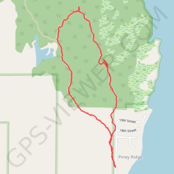
Ludington Park Loop
Loop hike in the Ludington State Park from Piney Ridge by the Hamlin Lake. #Hiking #Loop #Forest #Nature #Park #Lake
- Distance: 3.5 Km
- Elevation gain: 32 m
- Maximum elevation: 204 m
- Elevation loss: 31 m
- Minimum elevation: 188 m
- Moving time: 54 m 16 s
- Moving speed: 3.9 Km/h
- Maximum speed: 19.2 Km/h
- Total time: 55 m 38 s
- Global speed: 3.8 Km/h
Interactive trail map
Thank you for supporting this site ❤️
Make a donation
Make a donation
Gear up for your next adventure:
As an Amazon Associate, this site earns from qualifying purchases at no extra cost to you.
Trail profile
- Distance: 3.5 Km
- Elevation gain: 32 m
- Maximum elevation: 204 m
- Elevation loss: 31 m
- Minimum elevation: 188 m
- Moving time: 54 m 16 s
- Moving speed: 3.9 Km/h
- Maximum speed: 19.2 Km/h
- Total time: 55 m 38 s
- Global speed: 3.8 Km/h
Thank you for supporting this site ❤️
Make a donation
Make a donation
Gear up for your next adventure:
As an Amazon Associate, this site earns from qualifying purchases at no extra cost to you.
About this trail
Name: Ludington Park Loop trail, distance, elevation, map, profile, GPS track
Coordinates: 44.01446 -86.47955 44.02685 -86.47317
Thank you for supporting this site ❤️
Make a donation
Make a donation
Gear up for your next adventure:
As an Amazon Associate, this site earns from qualifying purchases at no extra cost to you.