Import a GPX file

Bump and Grind Trail

Loop hike from Palm Desert on the Bump and Grind Trail in the Santa Rosa and San Jacinto Mountains National Monument. #Hiking #Loop #Mountain #Desert #Nature

  • Distance: 6.5 Km
  • Elevation gain: 396 m
  • Maximum elevation: 391 m
  • Elevation loss: 394 m
  • Minimum elevation: 68 m

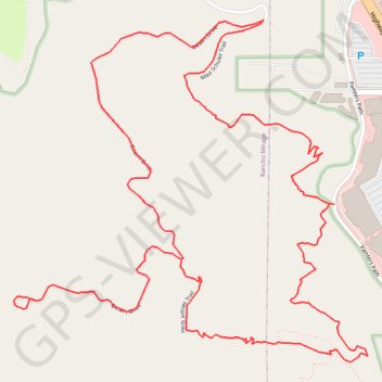
Interactive trail map

Trail profile

  • Distance: 6.5 Km
  • Elevation gain: 396 m
  • Maximum elevation: 391 m
  • Elevation loss: 394 m
  • Minimum elevation: 68 m

About this trail

Other hiking, mountain biking, running and outdoor activity trails

Click on a trail to view its statistics, map and profile.

Art Smith Trail

United States > California > Riverside County

Hike on the Art Smith Trail in the Santa Rosa and San Jacinto Mountains National Monument. #Hiking #Desert #Nature #Mountains

Distance: 12.8 Km • Elevation gain: 707 m • Maximum elevation: 752 m

Gear up for your next adventure:

Bushcraft Tarp - Versatile emergency shelter or gear protection
🧥Softshell Hiking Jacket - The perfect balance of wind protection and breathability
🧭GPS Tracker - Track your location in remote areas safely
🥾Hiking Gaiters - Protect legs and shoes from mud, snow, and debris
🥾Trekking Boots - Durable boots for long-distance trekking

As an Amazon Associate, this site earns from qualifying purchases at no extra cost to you.