Thank you for supporting this site ❤️
Make a donation
Make a donation
Gear up for your next adventure:
As an Amazon Associate, this site earns from qualifying purchases at no extra cost to you.
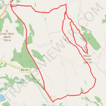
Waun-y-Llyn and Coed Talon Bank loop
- Distance: 8.6 Km
- Elevation gain: 204 m
- Maximum elevation: 285 m
- Elevation loss: 204 m
- Minimum elevation: 139 m
- Moving time: 1 h 49 m
- Moving speed: 4.7 Km/h
- Maximum speed: 5.9 Km/h
- Total time: 1 h 55 m
- Global speed: 4.5 Km/h
Interactive trail map
Thank you for supporting this site ❤️
Make a donation
Make a donation
Gear up for your next adventure:
As an Amazon Associate, this site earns from qualifying purchases at no extra cost to you.
Trail profile
- Distance: 8.6 Km
- Elevation gain: 204 m
- Maximum elevation: 285 m
- Elevation loss: 204 m
- Minimum elevation: 139 m
- Moving time: 1 h 49 m
- Moving speed: 4.7 Km/h
- Maximum speed: 5.9 Km/h
- Total time: 1 h 55 m
- Global speed: 4.5 Km/h
Thank you for supporting this site ❤️
Make a donation
Make a donation
Gear up for your next adventure:
As an Amazon Associate, this site earns from qualifying purchases at no extra cost to you.
About this trail
Name: Waun-y-Llyn and Coed Talon Bank loop trail, distance, elevation, map, profile, GPS track
Coordinates: 53.10415 -3.09404 53.12242 -3.06762
Thank you for supporting this site ❤️
Make a donation
Make a donation
Gear up for your next adventure:
As an Amazon Associate, this site earns from qualifying purchases at no extra cost to you.