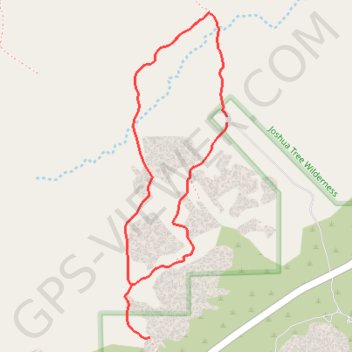
Split Rock and Face Rock Loop
Interactive trail map
Trail profile
- Distance: 3.7 Km
- Elevation gain: 92 m
- Maximum elevation: 1,335 m
- Elevation loss: 92 m
- Minimum elevation: 1,286 m
About this trail
Name: Split Rock and Face Rock Loop trail, distance, elevation, map, profile, GPS track
Start: Split Rock Trail, Riverside County, California, United States (34.00959 -116.05589)
End: Split Rock Trail, Riverside County, California, United States (34.00935 -116.05588)
Coordinates: 34.00055 -116.06090 34.01382 -116.05588
Other hiking, mountain biking, running and outdoor activity trails
Click on a trail to view its statistics, map and profile.