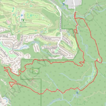
Cougar Mountain Regional Wildland Park - Loop hike from Red Town trailhead
- Distance: 9.0 Km
- Elevation gain: 308 m
- Maximum elevation: 324 m
- Elevation loss: 307 m
- Minimum elevation: 158 m
- Moving time: 2 h 27 m
- Moving speed: 3.7 Km/h
- Maximum speed: 7.6 Km/h
- Total time: 2 h 52 m
- Global speed: 3.1 Km/h
Interactive trail map
Trail profile
- Distance: 9.0 Km
- Elevation gain: 308 m
- Maximum elevation: 324 m
- Elevation loss: 307 m
- Minimum elevation: 158 m
- Moving time: 2 h 27 m
- Moving speed: 3.7 Km/h
- Maximum speed: 7.6 Km/h
- Total time: 2 h 52 m
- Global speed: 3.1 Km/h
About this trail
Name: Cougar Mountain Regional Wildland Park - Loop hike from Red Town trailhead trail, distance, elevation, map, profile, GPS track
Coordinates: 47.52083 -122.14762 47.53569 -122.12141
Other hiking, mountain biking, running and outdoor activity trails
Click on a trail to view its statistics, map and profile.
Coal Creek Falls Loop Trail in Cougar Mountain Regional Wildland Park
United States > Washington > King County > Coal Creek
The Coal Creek Falls Loop Trail in Cougar Mountain Regional Wildland Park offers hikers a tranquil journey leading to the charming Coal Creek Falls. Along the path, adorned with wooden bridges and rich foliage,, visitors can enjoy the serene ambiance of the forested landscape and the gentle sounds of the…
Distance: 4.6 Km • Elevation gain: 179 m • Maximum elevation: 331 m
Northern part of the Pacific Crest Trail (PCT)
United States > Oregon > Klamath County
Hike on the Pacific Crest National Scenic Trail from Crater Lake to Canada Border through Oregon and Washington along the Sierra Nevada and Cascade mountain ranges. #Hiking #Mountain #SierraNevada #Cascade #Nature #Forest #Park #PCT
Distance: 1,198.3 Km • Elevation gain: 44,308 m • Maximum elevation: 2,307 m
Cougar Mountain Loop Hike
United States > Washington > King County > Renton > Coal Creek
Distance: 11.2 Km • Elevation gain: 376 m • Maximum elevation: 455 m