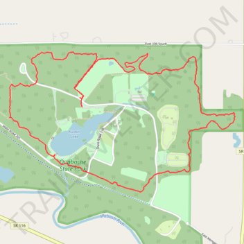
Most of Trail 5 in Ouabache State Park
- Distance: 8.5 Km
- Elevation gain: 43 m
- Maximum elevation: 269 m
- Elevation loss: 42 m
- Minimum elevation: 248 m
- Moving time: 1 h 48 m
- Moving speed: 4.7 Km/h
- Maximum speed: 11.3 Km/h
- Total time: 2 h 28 m
- Global speed: 3.4 Km/h
Interactive trail map
Trail profile
- Distance: 8.5 Km
- Elevation gain: 43 m
- Maximum elevation: 269 m
- Elevation loss: 42 m
- Minimum elevation: 248 m
- Moving time: 1 h 48 m
- Moving speed: 4.7 Km/h
- Maximum speed: 11.3 Km/h
- Total time: 2 h 28 m
- Global speed: 3.4 Km/h
About this trail
Name: Most of Trail 5 in Ouabache State Park trail, distance, elevation, map, profile, GPS track
Start: Trail 1, Wells County, Indiana, United States (40.72274 -85.10687)
End: Wells County, Indiana, United States (40.72351 -85.10712)
Coordinates: 40.71567 -85.11487 40.72731 -85.09011