Thank you for supporting this site ❤️
Make a donation
Make a donation
Gear up for your next adventure:
As an Amazon Associate, this site earns from qualifying purchases at no extra cost to you.
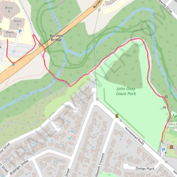
John Okey Davis Park
- Distance: 1.2 Km
- Elevation gain: 8 m
- Maximum elevation: 18 m
- Elevation loss: 12 m
- Minimum elevation: 8 m
- Moving time: 13 m 42 s
- Moving speed: 5.4 Km/h
- Maximum speed: 8.2 Km/h
- Total time: 13 m 42 s
- Global speed: 5.4 Km/h
Interactive trail map
Thank you for supporting this site ❤️
Make a donation
Make a donation
Gear up for your next adventure:
As an Amazon Associate, this site earns from qualifying purchases at no extra cost to you.
Trail profile
- Distance: 1.2 Km
- Elevation gain: 8 m
- Maximum elevation: 18 m
- Elevation loss: 12 m
- Minimum elevation: 8 m
- Moving time: 13 m 42 s
- Moving speed: 5.4 Km/h
- Maximum speed: 8.2 Km/h
- Total time: 13 m 42 s
- Global speed: 5.4 Km/h
Thank you for supporting this site ❤️
Make a donation
Make a donation
Gear up for your next adventure:
As an Amazon Associate, this site earns from qualifying purchases at no extra cost to you.
About this trail
Name: John Okey Davis Park trail, distance, elevation, map, profile, GPS track
Start: Homestead Road, Gosnells, City of Gosnells, Western Australia, 6108, Australia (-32.06375 115.98159)
Coordinates: -32.06375 115.97564 -32.06025 115.98188
Thank you for supporting this site ❤️
Make a donation
Make a donation
Gear up for your next adventure:
As an Amazon Associate, this site earns from qualifying purchases at no extra cost to you.