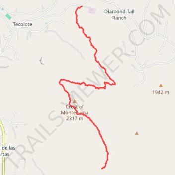
Montezuma Crest Trail (MCT)
- Distance: 4.7 Km
- Elevation gain: 308 m
- Maximum elevation: 2,132 m
- Elevation loss: 61 m
- Minimum elevation: 1,861 m
- Moving time: 45 m 41 s
- Moving speed: 6.1 Km/h
- Maximum speed: 7.1 Km/h
- Total time: 45 m 41 s
- Global speed: 6.1 Km/h
Interactive trail map
Trail profile
- Distance: 4.7 Km
- Elevation gain: 308 m
- Maximum elevation: 2,132 m
- Elevation loss: 61 m
- Minimum elevation: 1,861 m
- Moving time: 45 m 41 s
- Moving speed: 6.1 Km/h
- Maximum speed: 7.1 Km/h
- Total time: 45 m 41 s
- Global speed: 6.1 Km/h
About this trail
Name: Montezuma Crest Trail (MCT) trail, distance, elevation, map, profile, GPS track
Start: Diamond Tail Road, Tecolote, Sandoval County, New Mexico, United States (35.32199 -106.39517)
End: Perdiz Canyon Trail, Las Huertas, Sandoval County, New Mexico, United States (35.29889 -106.39169)
Coordinates: 35.29889 -106.39914 35.32204 -106.38930