Thank you for supporting this site ❤️
Make a donation
Make a donation
Gear up for your next adventure:
As an Amazon Associate, this site earns from qualifying purchases at no extra cost to you.
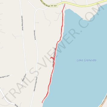
Lake Gleneida Walking Trail
- Distance: 2.3 Km
- Elevation gain: 46 m
- Maximum elevation: 179 m
- Elevation loss: 49 m
- Minimum elevation: 157 m
- Moving time: 26 m 15 s
- Moving speed: 5.2 Km/h
- Maximum speed: 7.6 Km/h
- Total time: 27 m 45 s
- Global speed: 5.0 Km/h
Interactive trail map
Thank you for supporting this site ❤️
Make a donation
Make a donation
Gear up for your next adventure:
As an Amazon Associate, this site earns from qualifying purchases at no extra cost to you.
Trail profile
- Distance: 2.3 Km
- Elevation gain: 46 m
- Maximum elevation: 179 m
- Elevation loss: 49 m
- Minimum elevation: 157 m
- Moving time: 26 m 15 s
- Moving speed: 5.2 Km/h
- Maximum speed: 7.6 Km/h
- Total time: 27 m 45 s
- Global speed: 5.0 Km/h
Thank you for supporting this site ❤️
Make a donation
Make a donation
Gear up for your next adventure:
As an Amazon Associate, this site earns from qualifying purchases at no extra cost to you.
About this trail
Name: Lake Gleneida Walking Trail trail, distance, elevation, map, profile, GPS track
Coordinates: 41.41622 -73.68918 41.42582 -73.68623
Thank you for supporting this site ❤️
Make a donation
Make a donation
Gear up for your next adventure:
As an Amazon Associate, this site earns from qualifying purchases at no extra cost to you.
Other hiking, mountain biking, running and outdoor activity trails
Click on a trail to view its statistics, map and profile.