Thank you for supporting this site ❤️
Make a donation
Make a donation
Gear up for your next adventure:
As an Amazon Associate, this site earns from qualifying purchases at no extra cost to you.
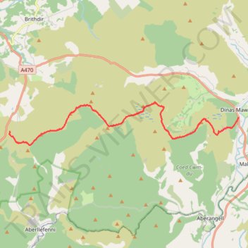
Dinas Mawddy to Cadair Idris
- Distance: 15.2 Km
- Elevation gain: 1,097 m
- Maximum elevation: 673 m
- Elevation loss: 856 m
- Minimum elevation: 105 m
- Moving time: 6 h 10 m
- Moving speed: 2.5 Km/h
- Maximum speed: 5.1 Km/h
- Total time: 7 h 35 m
- Global speed: 2.0 Km/h
Interactive trail map
Thank you for supporting this site ❤️
Make a donation
Make a donation
Gear up for your next adventure:
As an Amazon Associate, this site earns from qualifying purchases at no extra cost to you.
Trail profile
- Distance: 15.2 Km
- Elevation gain: 1,097 m
- Maximum elevation: 673 m
- Elevation loss: 856 m
- Minimum elevation: 105 m
- Moving time: 6 h 10 m
- Moving speed: 2.5 Km/h
- Maximum speed: 5.1 Km/h
- Total time: 7 h 35 m
- Global speed: 2.0 Km/h
Thank you for supporting this site ❤️
Make a donation
Make a donation
Gear up for your next adventure:
As an Amazon Associate, this site earns from qualifying purchases at no extra cost to you.
About this trail
Name: Dinas Mawddy to Cadair Idris trail, distance, elevation, map, profile, GPS track
Start: A470, Minllyn, Mawddwy, Dinas Mawddwy, Gwynedd, Wales, SY20 9LN, United Kingdom (52.71546 -3.69081)
End: A487, Dolgellau, Gwynedd, Wales, LL40 2RD, United Kingdom (52.70977 -3.83854)
Coordinates: 52.70450 -3.83869 52.72146 -3.69081
Thank you for supporting this site ❤️
Make a donation
Make a donation
Gear up for your next adventure:
As an Amazon Associate, this site earns from qualifying purchases at no extra cost to you.