Eumundi Conservation Park
Interactive trail map
Trail profile
- Distance: 7.1 Km
- Elevation gain: 116 m
- Maximum elevation: 79 m
- Elevation loss: 116 m
- Minimum elevation: 24 m
About this trail
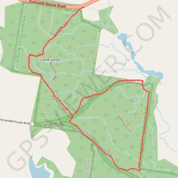
Name: Eumundi Conservation Park trail, distance, elevation, map, profile, GPS track
Start: Ajax Road, Verrierdale, Sunshine Coast Regional, Queensland, 4562, Australia (-26.47493 152.97744)
End: Ajax Road, Verrierdale, Sunshine Coast Regional, Queensland, 4562, Australia (-26.47492 152.97747)
Coordinates: -26.49234 152.97093 -26.47492 152.98518
Other hiking, mountain biking, running and outdoor activity trails
Click on a trail to view its statistics, map and profile.
Imbil Jimna Kenilworth loop
Australia > Queensland > Tewantin
Distance: 216.0 Km • Elevation gain: 3,884 m • Maximum elevation: 822 m