Thank you for supporting this site ❤️
Make a donation
Make a donation
Gear up for your next adventure:
As an Amazon Associate, this site earns from qualifying purchases at no extra cost to you.
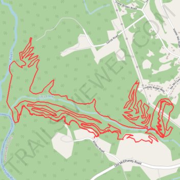
Saluda Confluence Recreation Area Mountain Bike Ride
- Distance: 27.1 Km
- Elevation gain: 551 m
- Maximum elevation: 332 m
- Elevation loss: 548 m
- Minimum elevation: 265 m
- Moving time: 1 h 41 m
- Moving speed: 16.0 Km/h
- Maximum speed: 34.8 Km/h
- Total time: 1 h 43 m
- Global speed: 15.8 Km/h
Interactive trail map
Thank you for supporting this site ❤️
Make a donation
Make a donation
Gear up for your next adventure:
As an Amazon Associate, this site earns from qualifying purchases at no extra cost to you.
Trail profile
- Distance: 27.1 Km
- Elevation gain: 551 m
- Maximum elevation: 332 m
- Elevation loss: 548 m
- Minimum elevation: 265 m
- Moving time: 1 h 41 m
- Moving speed: 16.0 Km/h
- Maximum speed: 34.8 Km/h
- Total time: 1 h 43 m
- Global speed: 15.8 Km/h
Thank you for supporting this site ❤️
Make a donation
Make a donation
Gear up for your next adventure:
As an Amazon Associate, this site earns from qualifying purchases at no extra cost to you.
About this trail
Name: Saluda Confluence Recreation Area Mountain Bike Ride trail, distance, elevation, map, profile, GPS track
Coordinates: 34.94924 -82.52398 34.96069 -82.50221
Thank you for supporting this site ❤️
Make a donation
Make a donation
Gear up for your next adventure:
As an Amazon Associate, this site earns from qualifying purchases at no extra cost to you.