Thank you for supporting this site ❤️
Make a donation
Make a donation
Gear up for your next adventure:
As an Amazon Associate, this site earns from qualifying purchases at no extra cost to you.
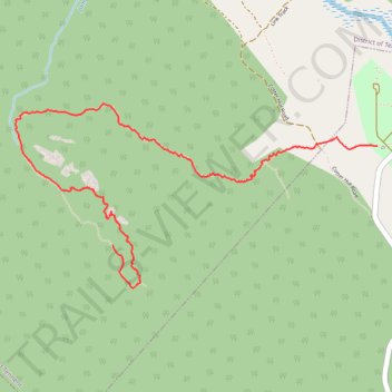
Granite Tors Walking Trail
- Distance: 4.9 Km
- Elevation gain: 7 m
- Maximum elevation: 1,318 m
- Elevation loss: 389 m
- Minimum elevation: 932 m
Interactive trail map
Thank you for supporting this site ❤️
Make a donation
Make a donation
Gear up for your next adventure:
As an Amazon Associate, this site earns from qualifying purchases at no extra cost to you.
Trail profile
- Distance: 4.9 Km
- Elevation gain: 7 m
- Maximum elevation: 1,318 m
- Elevation loss: 389 m
- Minimum elevation: 932 m
Thank you for supporting this site ❤️
Make a donation
Make a donation
Gear up for your next adventure:
As an Amazon Associate, this site earns from qualifying purchases at no extra cost to you.
About this trail
Name: Granite Tors Walking Trail trail, distance, elevation, map, profile, GPS track
Coordinates: -35.63652 148.93097 -35.62674 148.95473
Thank you for supporting this site ❤️
Make a donation
Make a donation
Gear up for your next adventure:
As an Amazon Associate, this site earns from qualifying purchases at no extra cost to you.
Other hiking, mountain biking, running and outdoor activity trails
Click on a trail to view its statistics, map and profile.
Cloudride24.FINAL
Distance: 1,028.8 Km • Elevation gain: 21,282 m • Maximum elevation: 1,754 m