Thank you for supporting this site ❤️
Make a donation
Make a donation
Gear up for your next adventure:
As an Amazon Associate, this site earns from qualifying purchases at no extra cost to you.
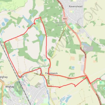
Gravel loop ride between Burntstump Country Park and Newstead Abbey Gardens
- Distance: 17.4 Km
- Elevation gain: 163 m
- Maximum elevation: 123 m
- Elevation loss: 152 m
- Minimum elevation: 64 m
- Moving time: 1 h 40 m
- Moving speed: 10.4 Km/h
- Maximum speed: 37.9 Km/h
- Total time: 2 h 45 m
- Global speed: 6.3 Km/h
Interactive trail map
Thank you for supporting this site ❤️
Make a donation
Make a donation
Gear up for your next adventure:
As an Amazon Associate, this site earns from qualifying purchases at no extra cost to you.
Trail profile
- Distance: 17.4 Km
- Elevation gain: 163 m
- Maximum elevation: 123 m
- Elevation loss: 152 m
- Minimum elevation: 64 m
- Moving time: 1 h 40 m
- Moving speed: 10.4 Km/h
- Maximum speed: 37.9 Km/h
- Total time: 2 h 45 m
- Global speed: 6.3 Km/h
Thank you for supporting this site ❤️
Make a donation
Make a donation
Gear up for your next adventure:
As an Amazon Associate, this site earns from qualifying purchases at no extra cost to you.
About this trail
Name: Gravel loop ride between Burntstump Country Park and Newstead Abbey Gardens trail, distance, elevation, map, profile, GPS track
Coordinates: 53.04779 -1.21835 53.08169 -1.14093
Thank you for supporting this site ❤️
Make a donation
Make a donation
Gear up for your next adventure:
As an Amazon Associate, this site earns from qualifying purchases at no extra cost to you.