Mount Katom and Shen Ramon
הר קטום ושן רמון: מההר שולחן של מכתש רמון למצפה רמון
- Distance: 26.1 Km
- Elevation gain: 1,106 m
- Maximum elevation: 865 m
- Elevation loss: 721 m
- Minimum elevation: 441 m
- Moving time: 7 h 56 m
- Moving speed: 3.3 Km/h
- Maximum speed: 4.0 Km/h
- Total time: 7 h 56 m
- Global speed: 3.3 Km/h
Interactive trail map
Trail profile
- Distance: 26.1 Km
- Elevation gain: 1,106 m
- Maximum elevation: 865 m
- Elevation loss: 721 m
- Minimum elevation: 441 m
- Moving time: 7 h 56 m
- Moving speed: 3.3 Km/h
- Maximum speed: 4.0 Km/h
- Total time: 7 h 56 m
- Global speed: 3.3 Km/h
About this trail
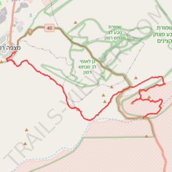
Name: Mount Katom and Shen Ramon trail, distance, elevation, map, profile, GPS track
Start: 40, Ramat Negev Regional Council, Beersheba Subdistrict, South District, Israel (30.56652 34.90351)
End: 40, Mizpe Ramon, Beersheba Subdistrict, South District, 8060000, Israel (30.60917 34.80710)
Coordinates: 30.56500 34.80077 30.60917 34.92004
Other hiking, mountain biking, running and outdoor activity trails
Click on a trail to view its statistics, map and profile.
Ramon to Sapir
Israel > South District > Ramat Negev Regional Council
מכתש רמון לספיר: ריצה חוצה מדבריות: מהר הנגב אל הערבה
Distance: 36.2 Km • Elevation gain: 856 m • Maximum elevation: 547 m