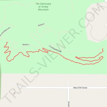
Turkey Mountain Rubble MTB Trail
- Distance: 1.4 Km
- Elevation gain: 12 m
- Maximum elevation: 257 m
- Elevation loss: 25 m
- Minimum elevation: 234 m
- Moving time: 19 m 3 s
- Moving speed: 4.4 Km/h
- Maximum speed: 6.6 Km/h
- Total time: 19 m 3 s
- Global speed: 4.4 Km/h
Interactive trail map
Trail profile
- Distance: 1.4 Km
- Elevation gain: 12 m
- Maximum elevation: 257 m
- Elevation loss: 25 m
- Minimum elevation: 234 m
- Moving time: 19 m 3 s
- Moving speed: 4.4 Km/h
- Maximum speed: 6.6 Km/h
- Total time: 19 m 3 s
- Global speed: 4.4 Km/h
About this trail
Name: Turkey Mountain Rubble MTB Trail trail, distance, elevation, map, profile, GPS track
Start: 3 Diamond Lane, Tulsa, Tulsa County, Oklahoma, 74132, United States (36.06920 -95.99593)
End: Checks and Balances, Tulsa, Tulsa County, Oklahoma, 74132, United States (36.06953 -96.00218)
Coordinates: 36.06833 -96.00242 36.06953 -95.99592
Other hiking, mountain biking, running and outdoor activity trails
Click on a trail to view its statistics, map and profile.
Turkey Mountain THE DAC MTB Trail
United States > Oklahoma > Tulsa County > Tulsa
Distance: 1.1 Km • Elevation gain: 15 m • Maximum elevation: 248 m