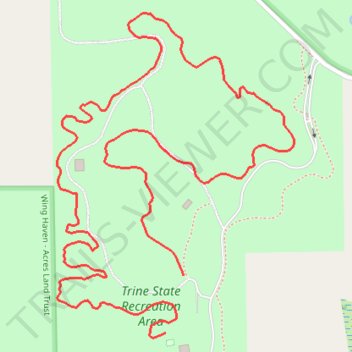
Trail 1 @ Trine State Recreation Area
- Distance: 3.2 Km
- Elevation gain: 26 m
- Maximum elevation: 316 m
- Elevation loss: 21 m
- Minimum elevation: 300 m
- Moving time: 53 m 39 s
- Moving speed: 3.5 Km/h
- Maximum speed: 8.4 Km/h
- Total time: 53 m 39 s
- Global speed: 3.5 Km/h
Interactive trail map
Trail profile
- Distance: 3.2 Km
- Elevation gain: 26 m
- Maximum elevation: 316 m
- Elevation loss: 21 m
- Minimum elevation: 300 m
- Moving time: 53 m 39 s
- Moving speed: 3.5 Km/h
- Maximum speed: 8.4 Km/h
- Total time: 53 m 39 s
- Global speed: 3.5 Km/h
About this trail
Name: Trail 1 @ Trine State Recreation Area trail, distance, elevation, map, profile, GPS track
Start: West Feather Valley Road, Steuben County, Indiana, 46737, United States (41.70901 -84.99713)
End: West Feather Valley Road, Steuben County, Indiana, 46737, United States (41.71010 -84.99669)
Coordinates: 41.70891 -84.99987 41.71507 -84.99387