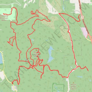
Fun enduro or dual sport tracks in the Oliphant area
- Distance: 66.4 Km
- Elevation gain: 2,391 m
- Maximum elevation: 589 m
- Elevation loss: 2,390 m
- Minimum elevation: 145 m
- Moving time: 3 h 51 m
- Moving speed: 17.2 Km/h
- Maximum speed: 66.9 Km/h
- Total time: 6 h 32 m
- Global speed: 10.2 Km/h
Interactive trail map
Trail profile
- Distance: 66.4 Km
- Elevation gain: 2,391 m
- Maximum elevation: 589 m
- Elevation loss: 2,390 m
- Minimum elevation: 145 m
- Moving time: 3 h 51 m
- Moving speed: 17.2 Km/h
- Maximum speed: 66.9 Km/h
- Total time: 6 h 32 m
- Global speed: 10.2 Km/h
About this trail
Name: Fun enduro or dual sport tracks in the Oliphant area trail, distance, elevation, map, profile, GPS track
Coordinates: 48.58204 -123.62226 48.63099 -123.54108
Topography: Area B (Shawnigan Lake) topographic map, elevation, terrain
Other hiking, mountain biking, running and outdoor activity trails
Click on a trail to view its statistics, map and profile.
Very nice, but challenging, enduro and trials loop in the Bamberton and Oliphant area
Canada > British Columbia > Cowichan Valley Regional District > Area A (Mill Bay / Malahat)
Distance: 29.6 Km • Elevation gain: 1,304 m • Maximum elevation: 557 m
BBF loop to the Skydeck in Nanaimo
Canada > British Columbia > Cowichan Valley Regional District > Area A (Mill Bay / Malahat) > Mill Bay
BBF loop to the Skydeck
Distance: 323.5 Km • Elevation gain: 6,222 m • Maximum elevation: 706 m