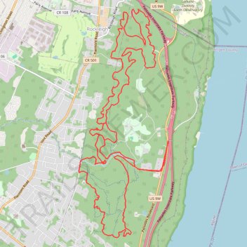
Alpine Rockleigh
- Distance: 24.7 Km
- Elevation gain: 620 m
- Maximum elevation: 171 m
- Elevation loss: 620 m
- Minimum elevation: 33 m
- Moving time: 3 h 6 m
- Moving speed: 8.0 Km/h
- Maximum speed: 36.4 Km/h
- Total time: 3 h 19 m
- Global speed: 7.4 Km/h
Interactive trail map
Trail profile
- Distance: 24.7 Km
- Elevation gain: 620 m
- Maximum elevation: 171 m
- Elevation loss: 620 m
- Minimum elevation: 33 m
- Moving time: 3 h 6 m
- Moving speed: 8.0 Km/h
- Maximum speed: 36.4 Km/h
- Total time: 3 h 19 m
- Global speed: 7.4 Km/h
About this trail
Name: Alpine Rockleigh trail, distance, elevation, map, profile, GPS track
Coordinates: 40.96277 -73.93482 41.00389 -73.91352
Other hiking, mountain biking, running and outdoor activity trails
Click on a trail to view its statistics, map and profile.
Giant Stairs Palisades Loop
United States > New Jersey > Bergen County > Alpine
Distance: 7.3 Km • Elevation gain: 483 m • Maximum elevation: 164 m
Long Path and Shore Loop in Palisades Interstate Park
United States > New Jersey > Bergen County > Alpine
This loop hike offers a captivating blend of natural beauty and rugged terrain, featuring panoramic views of the Hudson River and dramatic cliffs. Hikers can encounter diverse landscapes, including rocky descents, lush woodlands, and serene waterfronts, with spots ideal for resting and taking in the…
Distance: 9.8 Km • Elevation gain: 291 m • Maximum elevation: 169 m
Rockleigh Woods Sanctuary
United States > New Jersey > Bergen County > Rockleigh
Distance: 11.0 Km • Elevation gain: 325 m • Maximum elevation: 150 m
Peanut Leap Hike
United States > New Jersey > Bergen County > Alpine
Distance: 8.0 Km • Elevation gain: 386 m • Maximum elevation: 165 m
Palisades Interstate Park Mountain Bike Ride
United States > New Jersey > Bergen County > Rockleigh
Distance: 13.7 Km • Elevation gain: 330 m • Maximum elevation: 162 m
Palisades Interstate Park loop trails
United States > New Jersey > Bergen County > Alpine
Distance: 22.1 Km • Elevation gain: 518 m • Maximum elevation: 171 m
Old Croton Aqueduct Trail and Bronx
United States > New York > Westchester County > Village of Croton-on-Hudson
Distance: 70.8 Km • Elevation gain: 823 m • Maximum elevation: 80 m
Alpine & Rockleigh E-Biking
United States > New Jersey > Bergen County > Alpine
Distance: 26.0 Km • Elevation gain: 675 m • Maximum elevation: 171 m
Alpine & Rockleigh loop ride
United States > New Jersey > Bergen County > Alpine
Distance: 22.9 Km • Elevation gain: 550 m • Maximum elevation: 171 m
Alpine & Rockleigh
United States > New Jersey > Bergen County > Alpine
Palisades Interstate Park.
Distance: 15.0 Km • Elevation gain: 309 m • Maximum elevation: 171 m
Alpine & Rockleigh
United States > New Jersey > Bergen County > Alpine
Palisades Interstate Park
Distance: 20.3 Km • Elevation gain: 536 m • Maximum elevation: 171 m
Alpine & Rockleigh
United States > New Jersey > Bergen County > Alpine
Distance: 21.1 Km • Elevation gain: 526 m • Maximum elevation: 171 m
Alpine & Rockleigh
United States > New Jersey > Bergen County > Alpine
Distance: 19.9 Km • Elevation gain: 434 m • Maximum elevation: 171 m
Alpine Rockleigh
United States > New Jersey > Bergen County > Alpine
Distance: 23.7 Km • Elevation gain: 577 m • Maximum elevation: 171 m