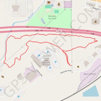
Brandon Quarry Loop Trail
The Brandon Quarry Loop Trail offers a moderately challenging hike through scenic landscapes near Brandon, Mississippi. The trail is popular for hiking and mountain biking, winding through wooded areas and offering tranquil views of the quarry, providing an enjoyable and peaceful outdoor experience. #Hiking #Loop #Forest #Nature #Lake
- Distance: 3.4 Km
- Elevation gain: 14 m
- Maximum elevation: 113 m
- Elevation loss: 14 m
- Minimum elevation: 99 m
- Moving time: 54 m 3 s
- Moving speed: 3.8 Km/h
- Maximum speed: 5.4 Km/h
- Total time: 54 m 3 s
- Global speed: 3.8 Km/h
Interactive trail map
Trail profile
- Distance: 3.4 Km
- Elevation gain: 14 m
- Maximum elevation: 113 m
- Elevation loss: 14 m
- Minimum elevation: 99 m
- Moving time: 54 m 3 s
- Moving speed: 3.8 Km/h
- Maximum speed: 5.4 Km/h
- Total time: 54 m 3 s
- Global speed: 3.8 Km/h
About this trail
Name: Brandon Quarry Loop Trail trail, distance, elevation, map, profile, GPS track
Start: Brandon, Rankin County, Mississippi, 39042, United States (32.27639 -90.01430)
Coordinates: 32.27609 -90.02271 32.27971 -90.01077