Indian Point Loop Trail in Garden of the Gods Wilderness
The Indian Point Loop Trail offers hikers an immersive experience through diverse forest landscapes and stunning sandstone bluffs. Following the ridge leads to several panoramic overlooks, including views of Hicks Dome and the Shawnee hills, revealing a landscape rich in geological history and scenic beauty. Though relatively short, the trail provides both cliffside vantage points and lower forest trails, where one can explore overhangs, rock formations, and secluded spots for camping, ideal for hikers seeking a blend of solitude and natural grandeur. #Hiking #Loop #Rock #Cliff #Forest #Nature
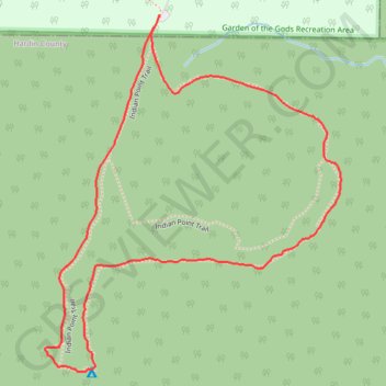
- Distance: 2.8 Km
- Elevation gain: 57 m
- Maximum elevation: 253 m
- Elevation loss: 57 m
- Minimum elevation: 218 m
- Moving time: 43 m 41 s
- Moving speed: 3.8 Km/h
- Maximum speed: 10.2 Km/h
- Total time: 48 m 36 s
- Global speed: 3.5 Km/h
Interactive trail map
Trail profile
- Distance: 2.8 Km
- Elevation gain: 57 m
- Maximum elevation: 253 m
- Elevation loss: 57 m
- Minimum elevation: 218 m
- Moving time: 43 m 41 s
- Moving speed: 3.8 Km/h
- Maximum speed: 10.2 Km/h
- Total time: 48 m 36 s
- Global speed: 3.5 Km/h
About this trail
Name: Indian Point Loop Trail in Garden of the Gods Wilderness trail, distance, elevation, map, profile, GPS track
Start: Indian Point Trail, Saline County, Illinois, 62947, United States (37.59978 -88.38148)
Coordinates: 37.59229 -88.38447 37.60005 -88.37634