Make a donation
Gear up for your next adventure:
As an Amazon Associate, this site earns from qualifying purchases at no extra cost to you.
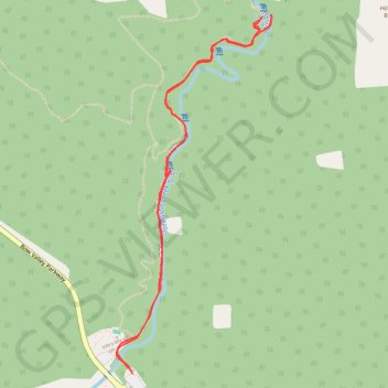
Johnston Canyon - Upper Falls
Johnston Creek. #Hiking #Snowshoeing #River #Falls #Forest
- Distance: 5.0 Km
- Elevation gain: 213 m
- Maximum elevation: 1,559 m
- Elevation loss: 213 m
- Minimum elevation: 1,435 m
Interactive trail map
Make a donation
Gear up for your next adventure:
As an Amazon Associate, this site earns from qualifying purchases at no extra cost to you.
Trail profile
- Distance: 5.0 Km
- Elevation gain: 213 m
- Maximum elevation: 1,559 m
- Elevation loss: 213 m
- Minimum elevation: 1,435 m
Make a donation
Gear up for your next adventure:
As an Amazon Associate, this site earns from qualifying purchases at no extra cost to you.
About this trail
Name: Johnston Canyon - Upper Falls trail, distance, elevation, map, profile, GPS track
Coordinates: 51.24575 -115.84100 51.26143 -115.83018
Topography: Improvement District No. 9 topographic map, elevation, terrain
Make a donation
Gear up for your next adventure:
As an Amazon Associate, this site earns from qualifying purchases at no extra cost to you.
Other hiking, mountain biking, running and outdoor activity trails
Click on a trail to view its statistics, map and profile.
Johnston Canyon - Ink Pots
Canada > Alberta > Improvement District No. 9
Banff National Park. #Hiking #Snowshoeing #Banff
Distance: 11.7 Km • Elevation gain: 498 m • Maximum elevation: 1,742 m