Thank you for supporting this site ❤️
Make a donation
Make a donation
Gear up for your next adventure:
As an Amazon Associate, this site earns from qualifying purchases at no extra cost to you.
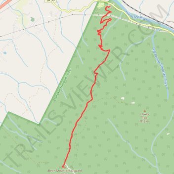
Bean Mountain / Oswald Dome via Lowry Cove Trail in Cherokee National Forest
- Distance: 12.7 Km
- Elevation gain: 732 m
- Maximum elevation: 916 m
- Elevation loss: 733 m
- Minimum elevation: 239 m
- Moving time: 2 h 29 m
- Moving speed: 5.1 Km/h
- Maximum speed: 7.6 Km/h
- Total time: 2 h 31 m
- Global speed: 5.0 Km/h
Interactive trail map
Thank you for supporting this site ❤️
Make a donation
Make a donation
Gear up for your next adventure:
As an Amazon Associate, this site earns from qualifying purchases at no extra cost to you.
Trail profile
- Distance: 12.7 Km
- Elevation gain: 732 m
- Maximum elevation: 916 m
- Elevation loss: 733 m
- Minimum elevation: 239 m
- Moving time: 2 h 29 m
- Moving speed: 5.1 Km/h
- Maximum speed: 7.6 Km/h
- Total time: 2 h 31 m
- Global speed: 5.0 Km/h
Thank you for supporting this site ❤️
Make a donation
Make a donation
Gear up for your next adventure:
As an Amazon Associate, this site earns from qualifying purchases at no extra cost to you.
About this trail
Name: Bean Mountain / Oswald Dome via Lowry Cove Trail in Cherokee National Forest trail, distance, elevation, map, profile, GPS track
Coordinates: 35.19197 -84.55878 35.22889 -84.54512
Thank you for supporting this site ❤️
Make a donation
Make a donation
Gear up for your next adventure:
As an Amazon Associate, this site earns from qualifying purchases at no extra cost to you.