Indian Trail and Finger Lakes/North Country Trail Loop in Watkins Glen State Park
The Indian Trail and Finger Lakes/North Country Trail Loop in Watkins Glen State Park showcases the park's diverse landscapes, from dramatic gorges to serene woodland paths. Hikers are treated to breathtaking views of the winding Glen Creek and cascading waterfalls, including the renowned Rainbow Falls, complemented by overlooks like the historic suspension bridge. The trail balances rugged natural beauty with well-maintained routes, offering both challenge and tranquility in one of New York's most iconic state parks. #Hiking #Gorge #Forest #Nature #River #Waterfall #Canyon
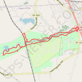
- Distance: 7.4 Km
- Elevation gain: 232 m
- Maximum elevation: 317 m
- Elevation loss: 232 m
- Minimum elevation: 146 m
- Moving time: 1 h 40 m
- Moving speed: 4.4 Km/h
- Maximum speed: 15.9 Km/h
- Total time: 1 h 46 m
- Global speed: 4.2 Km/h
Interactive trail map
Trail profile
- Distance: 7.4 Km
- Elevation gain: 232 m
- Maximum elevation: 317 m
- Elevation loss: 232 m
- Minimum elevation: 146 m
- Moving time: 1 h 40 m
- Moving speed: 4.4 Km/h
- Maximum speed: 15.9 Km/h
- Total time: 1 h 46 m
- Global speed: 4.2 Km/h
About this trail
Name: Indian Trail and Finger Lakes/North Country Trail Loop in Watkins Glen State Park trail, distance, elevation, map, profile, GPS track
Coordinates: 42.36782 -76.90086 42.37614 -76.87091
Other hiking, mountain biking, running and outdoor activity trails
Click on a trail to view its statistics, map and profile.
Indian Trail in Watkins Glen State Park
United States > New York > Schuyler County > Watkins Glen
The Indian Trail in Watkins Glen State Park offers a more peaceful route compared to the park's main gorge trail. It meanders along the north rim of the gorge, providing distant views of the impressive rock formations and waterfalls like Rainbow Falls below. Notably, hikers will cross a suspension bridge,…
Distance: 3.9 Km • Elevation gain: 150 m • Maximum elevation: 298 m
Glen Creek Gorge Loop via Gorge Trail and Indian Trail in Watkins Glen State Park
United States > New York > Schuyler County > Watkins Glen
The Glen Creek Gorge Loop offers a captivating hiking experience through a stunning landscape of waterfalls, narrow gorges, and unique rock formations. As you traverse the Gorge Trail, highlights include the dramatic Sentry Bridge and the enchanting Cavern Cascade, where the trail actually takes you behind the…
Distance: 3.9 Km • Elevation gain: 138 m • Maximum elevation: 297 m