Import a GPX file

Side by Side ride around the Iron Range using the OHV Trails

  • Distance: 22.6 Km
  • Elevation gain: 270 m
  • Maximum elevation: 543 m
  • Elevation loss: 288 m
  • Minimum elevation: 451 m
  • Moving time: 1 h 14 m
  • Moving speed: 18.2 Km/h
  • Maximum speed: 61.1 Km/h
  • Total time: 1 h 25 m
  • Global speed: 16.0 Km/h

Interactive trail map

Trail profile

  • Distance: 22.6 Km
  • Elevation gain: 270 m
  • Maximum elevation: 543 m
  • Elevation loss: 288 m
  • Minimum elevation: 451 m
  • Moving time: 1 h 14 m
  • Moving speed: 18.2 Km/h
  • Maximum speed: 61.1 Km/h
  • Total time: 1 h 25 m
  • Global speed: 16.0 Km/h

About this trail
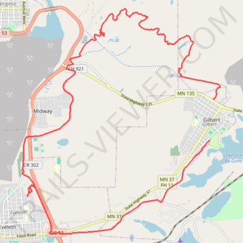
Name: Side by Side ride around the Iron Range using the OHV Trails trail, distance, elevation, map, profile, GPS track

Start: Holiday Stationstore, Summit Street North, Gilbert, Saint Louis County, Minnesota, 55741, United States (47.49392 -92.46452)

End: Mesabi Trail, Gilbert, Sparta, Gilbert, Saint Louis County, Minnesota, 55734, United States (47.48381 -92.46614)

Coordinates: 47.46111 -92.53320 47.51582 -92.46208

Gear up for your next adventure:

🧭Orienteering Kit - Tools for map reading and navigation in the wild
🥾Trekking Poles - Adjustable trekking poles to reduce knee stress and improve stability
🦶Anti-Blister Balm - Prevents friction and hotspots during long ascents
🎒Backpack Rain Cover - External shield to keep your entire pack dry
🧢Sun Protection Cap - Breathable cap to protect from sun exposure

As an Amazon Associate, this site earns from qualifying purchases at no extra cost to you.