Make a donation
Gear up for your next adventure:
As an Amazon Associate, this site earns from qualifying purchases at no extra cost to you.
New
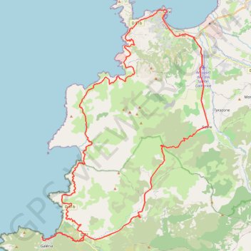
- Distance: 70.0 Km
- Elevation gain: 1,409 m
- Maximum elevation: 440 m
- Elevation loss: 1,409 m
- Minimum elevation: 1 m
Interactive trail map
Make a donation
Gear up for your next adventure:
As an Amazon Associate, this site earns from qualifying purchases at no extra cost to you.
Trail profile
- Distance: 70.0 Km
- Elevation gain: 1,409 m
- Maximum elevation: 440 m
- Elevation loss: 1,409 m
- Minimum elevation: 1 m
Make a donation
Gear up for your next adventure:
As an Amazon Associate, this site earns from qualifying purchases at no extra cost to you.
About this trail
Name: New trail, distance, elevation, map, profile, GPS track
Coordinates: 42.41114 8.64364 42.56879 8.79734
Make a donation
Gear up for your next adventure:
As an Amazon Associate, this site earns from qualifying purchases at no extra cost to you.
Other hiking, mountain biking, running and outdoor activity trails
Click on a trail to view its statistics, map and profile.
1 LUCENA - MONTPELLIER
Distance: 2,964.4 Km • Elevation gain: 29,500 m • Maximum elevation: 1,048 m
New
France > Corsica > Haute-Corse > Monticello
Distance: 40.2 Km • Elevation gain: 837 m • Maximum elevation: 536 m
New
France > Corsica > Haute-Corse > Monticello
Distance: 50.0 Km • Elevation gain: 1,023 m • Maximum elevation: 536 m