Thank you for supporting this site ❤️
Make a donation
Make a donation
Gear up for your next adventure:
As an Amazon Associate, this site earns from qualifying purchases at no extra cost to you.
Fooses Reroute
- Distance: 16.3 Km
- Elevation gain: 51 m
- Maximum elevation: 3,637 m
- Elevation loss: 982 m
- Minimum elevation: 2,692 m
- Moving time: 4 h 30 m
- Moving speed: 3.6 Km/h
- Maximum speed: 3.9 Km/h
- Total time: 4 h 30 m
- Global speed: 3.6 Km/h
Interactive trail map
Thank you for supporting this site ❤️
Make a donation
Make a donation
Gear up for your next adventure:
As an Amazon Associate, this site earns from qualifying purchases at no extra cost to you.
Trail profile
- Distance: 16.3 Km
- Elevation gain: 51 m
- Maximum elevation: 3,637 m
- Elevation loss: 982 m
- Minimum elevation: 2,692 m
- Moving time: 4 h 30 m
- Moving speed: 3.6 Km/h
- Maximum speed: 3.9 Km/h
- Total time: 4 h 30 m
- Global speed: 3.6 Km/h
Thank you for supporting this site ❤️
Make a donation
Make a donation
Gear up for your next adventure:
As an Amazon Associate, this site earns from qualifying purchases at no extra cost to you.
About this trail
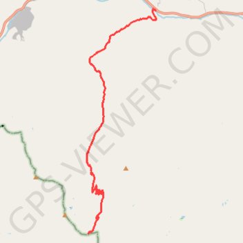
Name: Fooses Reroute trail, distance, elevation, map, profile, GPS track
Start: Colorado Trail (Segment 15), Chaffee County, Colorado, United States (38.45450 -106.27705)
End: Colorado Trail (Segment 14), Chaffee County, Colorado, 81227, United States (38.54327 -106.24252)
Coordinates: 38.45450 -106.27773 38.54379 -106.24251
Thank you for supporting this site ❤️
Make a donation
Make a donation
Gear up for your next adventure:
As an Amazon Associate, this site earns from qualifying purchases at no extra cost to you.