Import a GPX file

Derby Tracks - Long Shadows - Return to Sender

#Hiking #MTB #Loop #Tasmania

  • Distance: 11.6 Km
  • Elevation gain: 376 m
  • Maximum elevation: 415 m
  • Elevation loss: 376 m
  • Minimum elevation: 146 m

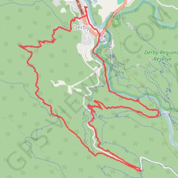
Interactive trail map

Trail profile

  • Distance: 11.6 Km
  • Elevation gain: 376 m
  • Maximum elevation: 415 m
  • Elevation loss: 376 m
  • Minimum elevation: 146 m

About this trail

Name: Derby Tracks - Long Shadows - Return to Sender trail, distance, elevation, map, profile, GPS track

Start: Esplanade, Derby, Dorset, Tasmania, 7264, Australia (-41.14625 147.80214)

End: Esplanade, Derby, Dorset, Tasmania, 7264, Australia (-41.14625 147.80214)

Coordinates: -41.16953 147.78929 -41.14612 147.81563

Other hiking, mountain biking, running and outdoor activity trails

Click on a trail to view its statistics, map and profile.

Weldborough - Derby

Australia > Tasmania > Derby

Atlas MTB Trail. Derby Regional Reserve. #MTB #Derby #Tasmania

Distance: 14.5 Km • Elevation gain: 201 m • Maximum elevation: 646 m

MTB - Derby - Longshadows upper and 333 down

Australia > Tasmania > Derby

Distance: 12.7 Km • Elevation gain: 390 m • Maximum elevation: 421 m

MTB - Derby

Australia > Tasmania > Derby

Distance: 13.5 Km • Elevation gain: 486 m • Maximum elevation: 412 m

Gear up for your next adventure:

🛌Down Sleeping Bag - Superior warmth-to-weight ratio for cold nights
🍽️Titanium Camping Spork - Ultralight and indestructible eating utensil
🥾Hiking Gaiters - Protect legs and shoes from mud, snow, and debris
🧥Softshell Hiking Jacket - The perfect balance of wind protection and breathability
🥾Trail Running Boots - Durable shoes designed for trail running

As an Amazon Associate, this site earns from qualifying purchases at no extra cost to you.