Thank you for supporting this site ❤️
Make a donation
Make a donation
Gear up for your next adventure:
As an Amazon Associate, this site earns from qualifying purchases at no extra cost to you.
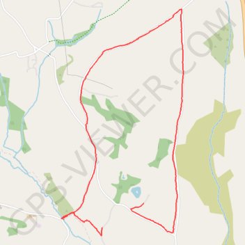
Devon walk
- Distance: 4.8 Km
- Elevation gain: 83 m
- Maximum elevation: 274 m
- Elevation loss: 66 m
- Minimum elevation: 206 m
- Moving time: 54 m 42 s
- Moving speed: 5.2 Km/h
- Maximum speed: 12.1 Km/h
- Total time: 1 h 1 m
- Global speed: 4.7 Km/h
Interactive trail map
Thank you for supporting this site ❤️
Make a donation
Make a donation
Gear up for your next adventure:
As an Amazon Associate, this site earns from qualifying purchases at no extra cost to you.
Trail profile
- Distance: 4.8 Km
- Elevation gain: 83 m
- Maximum elevation: 274 m
- Elevation loss: 66 m
- Minimum elevation: 206 m
- Moving time: 54 m 42 s
- Moving speed: 5.2 Km/h
- Maximum speed: 12.1 Km/h
- Total time: 1 h 1 m
- Global speed: 4.7 Km/h
Thank you for supporting this site ❤️
Make a donation
Make a donation
Gear up for your next adventure:
As an Amazon Associate, this site earns from qualifying purchases at no extra cost to you.
About this trail
Name: Devon walk trail, distance, elevation, map, profile, GPS track
Start: South Tawton, Throwleigh, West Devon, Devon, England, EX20 2JQ, United Kingdom (50.69919 -3.86936)
End: South Tawton, Throwleigh, West Devon, Devon, England, EX20 2JQ, United Kingdom (50.70079 -3.86498)
Coordinates: 50.69863 -3.87367 50.71383 -3.86076
Thank you for supporting this site ❤️
Make a donation
Make a donation
Gear up for your next adventure:
As an Amazon Associate, this site earns from qualifying purchases at no extra cost to you.