Thank you for supporting this site ❤️
Make a donation
Make a donation
Gear up for your next adventure:
As an Amazon Associate, this site earns from qualifying purchases at no extra cost to you.
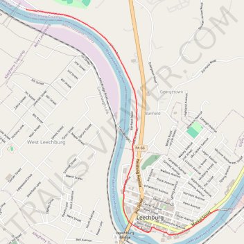
Leechburg Towpath Trail
- Distance: 3.9 Km
- Elevation gain: 40 m
- Maximum elevation: 249 m
- Elevation loss: 36 m
- Minimum elevation: 234 m
- Moving time: 12 m 48 s
- Moving speed: 18.1 Km/h
- Maximum speed: 24.3 Km/h
- Total time: 12 m 48 s
- Global speed: 18.1 Km/h
Interactive trail map
Thank you for supporting this site ❤️
Make a donation
Make a donation
Gear up for your next adventure:
As an Amazon Associate, this site earns from qualifying purchases at no extra cost to you.
Trail profile
- Distance: 3.9 Km
- Elevation gain: 40 m
- Maximum elevation: 249 m
- Elevation loss: 36 m
- Minimum elevation: 234 m
- Moving time: 12 m 48 s
- Moving speed: 18.1 Km/h
- Maximum speed: 24.3 Km/h
- Total time: 12 m 48 s
- Global speed: 18.1 Km/h
Thank you for supporting this site ❤️
Make a donation
Make a donation
Gear up for your next adventure:
As an Amazon Associate, this site earns from qualifying purchases at no extra cost to you.
About this trail
Name: Leechburg Towpath Trail trail, distance, elevation, map, profile, GPS track
Coordinates: 40.62551 -79.62057 40.64578 -79.59786
Thank you for supporting this site ❤️
Make a donation
Make a donation
Gear up for your next adventure:
As an Amazon Associate, this site earns from qualifying purchases at no extra cost to you.