Thank you for supporting this site ❤️
Make a donation
Make a donation
Gear up for your next adventure:
As an Amazon Associate, this site earns from qualifying purchases at no extra cost to you.
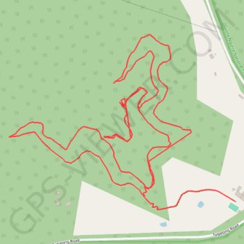
Attunga trails
Attunga trail mapping
- Distance: 6.0 Km
- Elevation gain: 320 m
- Maximum elevation: 729 m
- Elevation loss: 346 m
- Minimum elevation: 624 m
- Moving time: 51 m 39 s
- Moving speed: 6.9 Km/h
- Maximum speed: 23.7 Km/h
- Total time: 51 m 39 s
- Global speed: 6.9 Km/h
Interactive trail map
Thank you for supporting this site ❤️
Make a donation
Make a donation
Gear up for your next adventure:
As an Amazon Associate, this site earns from qualifying purchases at no extra cost to you.
Trail profile
- Distance: 6.0 Km
- Elevation gain: 320 m
- Maximum elevation: 729 m
- Elevation loss: 346 m
- Minimum elevation: 624 m
- Moving time: 51 m 39 s
- Moving speed: 6.9 Km/h
- Maximum speed: 23.7 Km/h
- Total time: 51 m 39 s
- Global speed: 6.9 Km/h
Thank you for supporting this site ❤️
Make a donation
Make a donation
Gear up for your next adventure:
As an Amazon Associate, this site earns from qualifying purchases at no extra cost to you.
About this trail
Name: Attunga trails trail, distance, elevation, map, profile, GPS track
Coordinates: -34.41830 150.14265 -34.41121 150.15375
Thank you for supporting this site ❤️
Make a donation
Make a donation
Gear up for your next adventure:
As an Amazon Associate, this site earns from qualifying purchases at no extra cost to you.