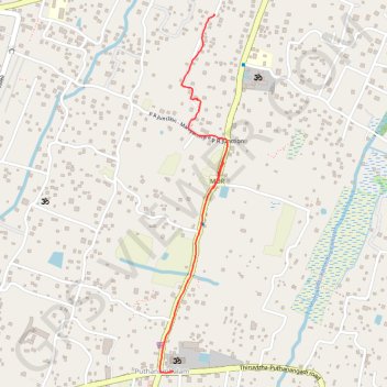
Kanjikkuzhi
- Distance: 2.1 Km
- Elevation gain: 3 m
- Maximum elevation: 10 m
- Elevation loss: 3 m
- Minimum elevation: 7 m
- Moving time: 9 m 59 s
- Moving speed: 12.4 Km/h
- Maximum speed: 35.0 Km/h
- Total time: 12 m 14 s
- Global speed: 10.1 Km/h
Interactive trail map
Trail profile
- Distance: 2.1 Km
- Elevation gain: 3 m
- Maximum elevation: 10 m
- Elevation loss: 3 m
- Minimum elevation: 7 m
- Moving time: 9 m 59 s
- Moving speed: 12.4 Km/h
- Maximum speed: 35.0 Km/h
- Total time: 12 m 14 s
- Global speed: 10.1 Km/h
About this trail
Name: Kanjikkuzhi trail, distance, elevation, map, profile, GPS track
Start: SCB-1817, Nanduveli Road, Cherthala, Alappuzha, Kerala, 688555, India (9.65440 76.35613)
Coordinates: 9.64140 76.35409 9.65442 76.35658
Other hiking, mountain biking, running and outdoor activity trails
Click on a trail to view its statistics, map and profile.
Thiruvizha
Distance: 3.2 Km • Elevation gain: 5 m • Maximum elevation: 10 m