Thank you for supporting this site ❤️
Make a donation
Make a donation
Gear up for your next adventure:
As an Amazon Associate, this site earns from qualifying purchases at no extra cost to you.
Mount Pleasant (Rising Park)
Interactive trail map
Thank you for supporting this site ❤️
Make a donation
Make a donation
Gear up for your next adventure:
As an Amazon Associate, this site earns from qualifying purchases at no extra cost to you.
Trail profile
- Distance: 1.8 Km
- Elevation gain: 76 m
- Maximum elevation: 318 m
- Elevation loss: 76 m
- Minimum elevation: 268 m
- Moving time: 18 m 10 s
- Moving speed: 6.1 Km/h
- Maximum speed: 16.3 Km/h
- Total time: 19 m 52 s
- Global speed: 5.6 Km/h
Thank you for supporting this site ❤️
Make a donation
Make a donation
Gear up for your next adventure:
As an Amazon Associate, this site earns from qualifying purchases at no extra cost to you.
About this trail
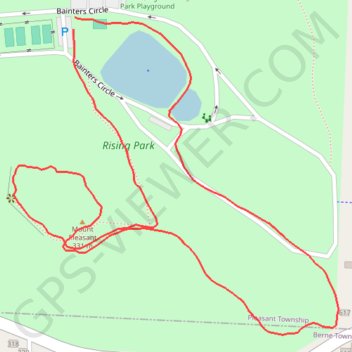
Name: Mount Pleasant (Rising Park) trail, distance, elevation, map, profile, GPS track
Coordinates: 39.72346 -82.59511 39.72719 -82.59014
Thank you for supporting this site ❤️
Make a donation
Make a donation
Gear up for your next adventure:
As an Amazon Associate, this site earns from qualifying purchases at no extra cost to you.