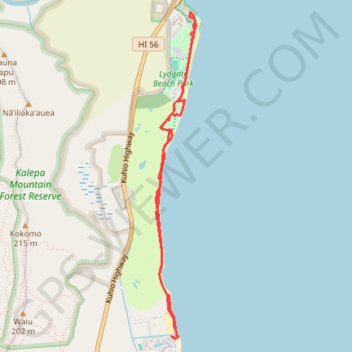
Nukolii Beach to Wailua River Park (Kauai Island)
Hike along the Pacific coast from Nukolii Beach Park to Wailua River State Park via Kauai Beach and Lydgate Beach on the Kaua'i Island. #Hiking #Beach #Coast #Sea #Pacific #Ocean #Island #Nature #Forest #Park #Hawaii
- Distance: 8.2 Km
- Elevation gain: 61 m
- Maximum elevation: 14 m
- Elevation loss: 62 m
- Minimum elevation: -1 m
- Moving time: 1 h 53 m
- Moving speed: 4.3 Km/h
- Maximum speed: 6.5 Km/h
- Total time: 1 h 53 m
- Global speed: 4.3 Km/h
Interactive trail map
Trail profile
- Distance: 8.2 Km
- Elevation gain: 61 m
- Maximum elevation: 14 m
- Elevation loss: 62 m
- Minimum elevation: -1 m
- Moving time: 1 h 53 m
- Moving speed: 4.3 Km/h
- Maximum speed: 6.5 Km/h
- Total time: 1 h 53 m
- Global speed: 4.3 Km/h
About this trail
Name: Nukolii Beach to Wailua River Park (Kauai Island) trail, distance, elevation, map, profile, GPS track
Start: Kauai Beach Drive, Kauaʻi County, Hawaii, 96766, United States (22.01154 -159.33748)
End: Kauai Beach Drive, Kauaʻi County, Hawaii, 96766, United States (22.01154 -159.33729)
Coordinates: 22.01132 -159.33909 22.04312 -159.33487