Thank you for supporting this site ❤️
Make a donation
Make a donation
Gear up for your next adventure:
As an Amazon Associate, this site earns from qualifying purchases at no extra cost to you.
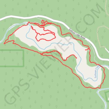
Hike at Mill Pond Historic Trail
Evening hike
- Distance: 8.5 Km
- Elevation gain: 227 m
- Maximum elevation: 819 m
- Elevation loss: 227 m
- Minimum elevation: 765 m
- Moving time: 1 h 47 m
- Moving speed: 4.7 Km/h
- Maximum speed: 16.6 Km/h
- Total time: 2 h 25 m
- Global speed: 3.5 Km/h
Interactive trail map
Thank you for supporting this site ❤️
Make a donation
Make a donation
Gear up for your next adventure:
As an Amazon Associate, this site earns from qualifying purchases at no extra cost to you.
Trail profile
- Distance: 8.5 Km
- Elevation gain: 227 m
- Maximum elevation: 819 m
- Elevation loss: 227 m
- Minimum elevation: 765 m
- Moving time: 1 h 47 m
- Moving speed: 4.7 Km/h
- Maximum speed: 16.6 Km/h
- Total time: 2 h 25 m
- Global speed: 3.5 Km/h
Thank you for supporting this site ❤️
Make a donation
Make a donation
Gear up for your next adventure:
As an Amazon Associate, this site earns from qualifying purchases at no extra cost to you.
About this trail
Name: Hike at Mill Pond Historic Trail trail, distance, elevation, map, profile, GPS track
Start: Mill Pond Picnic Area Road, Pend Oreille County, Washington, United States (48.85863 -117.30243)
End: Mill Pond Picnic Area Road, Pend Oreille County, Washington, United States (48.85865 -117.30245)
Coordinates: 48.85085 -117.30733 48.85902 -117.28902
Thank you for supporting this site ❤️
Make a donation
Make a donation
Gear up for your next adventure:
As an Amazon Associate, this site earns from qualifying purchases at no extra cost to you.