Wayland’s Smithy, Ridgeway, Savernake
- Distance: 73.8 Km
- Elevation gain: 967 m
- Maximum elevation: 277 m
- Elevation loss: 967 m
- Minimum elevation: 119 m
- Moving time: 5 h 22 m
- Moving speed: 13.7 Km/h
- Maximum speed: 60.9 Km/h
- Total time: 5 h 53 m
- Global speed: 12.5 Km/h
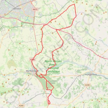
Interactive trail map
Trail profile
- Distance: 73.8 Km
- Elevation gain: 967 m
- Maximum elevation: 277 m
- Elevation loss: 967 m
- Minimum elevation: 119 m
- Moving time: 5 h 22 m
- Moving speed: 13.7 Km/h
- Maximum speed: 60.9 Km/h
- Total time: 5 h 53 m
- Global speed: 12.5 Km/h
About this trail
Name: Wayland’s Smithy, Ridgeway, Savernake trail, distance, elevation, map, profile, GPS track
Start: Martingale Road, Eastcourt, Burbage, Wiltshire, England, SN8 3TY, United Kingdom (51.34670 -1.66622)
End: Martingale Road, Eastcourt, Burbage, Wiltshire, England, SN8 3TY, United Kingdom (51.34668 -1.66616)
Coordinates: 51.34566 -1.73077 51.57166 -1.56967
Other hiking, mountain biking, running and outdoor activity trails
Click on a trail to view its statistics, map and profile.
Dean2023-311
United Kingdom > England > Oxfordshire > Oxford
Distance: 310.3 Km • Elevation gain: 3,366 m • Maximum elevation: 290 m