Au-dessus de Bormes-Les-Mimosas _ variante courte_2025-10-16_14-17-03
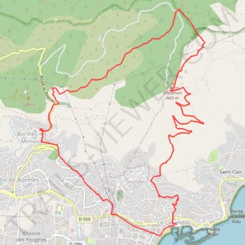
- Distance: 14.3 Km
- Elevation gain: 518 m
- Maximum elevation: 462 m
- Elevation loss: 520 m
- Minimum elevation: 2 m
Interactive trail map
Trail profile
- Distance: 14.3 Km
- Elevation gain: 518 m
- Maximum elevation: 462 m
- Elevation loss: 520 m
- Minimum elevation: 2 m
About this trail
Name: Au-dessus de Bormes-Les-Mimosas _ variante courte_2025-10-16_14-17-03 trail, distance, elevation, map, profile, GPS track
Coordinates: 43.13636 6.34343 43.16932 6.37627
Other hiking, mountain biking, running and outdoor activity trails
Click on a trail to view its statistics, map and profile.
1 LUCENA - MONTPELLIER
Distance: 2,964.4 Km • Elevation gain: 29,500 m • Maximum elevation: 1,048 m
PT23DS2 Lörrach → Cadaqués
Germany > Baden-Württemberg > Landkreis Lörrach > Lörrach (Kernstadt)
Distance: 1,050.7 Km • Elevation gain: 13,130 m • Maximum elevation: 1,505 m
AU DESSUS DE BORMES LES MIMOSAS
France > Provence-Alpes-Côte d'Azur > Var > Le Lavandou
Distance: 17.6 Km • Elevation gain: 722 m • Maximum elevation: 462 m