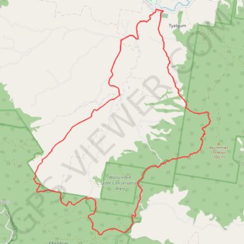
Tyalgum - Brummies Lookout - Cutters Camp
Interactive trail map
Trail profile
- Distance: 33.0 Km
- Elevation gain: 878 m
- Maximum elevation: 483 m
- Elevation loss: 877 m
- Minimum elevation: 52 m
About this trail
Name: Tyalgum - Brummies Lookout - Cutters Camp trail, distance, elevation, map, profile, GPS track
Start: Tyalgum Road, Tyalgum, Tweed Shire Council, New South Wales, 2484, Australia (-28.35923 153.21156)
End: Tyalgum Road, Tyalgum, Tweed Shire Council, New South Wales, 2484, Australia (-28.35927 153.21116)
Coordinates: -28.44601 153.15465 -28.35866 153.23241