Thank you for supporting this site ❤️
Make a donation
Make a donation
Gear up for your next adventure:
As an Amazon Associate, this site earns from qualifying purchases at no extra cost to you.
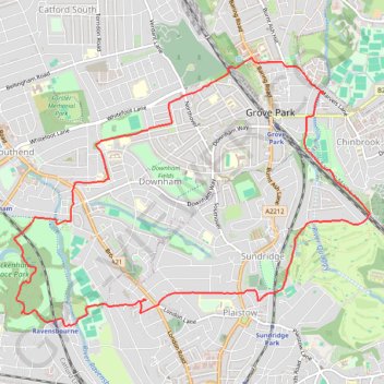
Beckenham Place Park
Morning Walk
- Distance: 11.5 Km
- Elevation gain: 132 m
- Maximum elevation: 67 m
- Elevation loss: 132 m
- Minimum elevation: 27 m
- Moving time: 2 h 31 m
- Moving speed: 4.5 Km/h
- Maximum speed: 7.3 Km/h
- Total time: 2 h 34 m
- Global speed: 4.5 Km/h
Interactive trail map
Thank you for supporting this site ❤️
Make a donation
Make a donation
Gear up for your next adventure:
As an Amazon Associate, this site earns from qualifying purchases at no extra cost to you.
Trail profile
- Distance: 11.5 Km
- Elevation gain: 132 m
- Maximum elevation: 67 m
- Elevation loss: 132 m
- Minimum elevation: 27 m
- Moving time: 2 h 31 m
- Moving speed: 4.5 Km/h
- Maximum speed: 7.3 Km/h
- Total time: 2 h 34 m
- Global speed: 4.5 Km/h
Thank you for supporting this site ❤️
Make a donation
Make a donation
Gear up for your next adventure:
As an Amazon Associate, this site earns from qualifying purchases at no extra cost to you.
About this trail
Name: Beckenham Place Park trail, distance, elevation, map, profile, GPS track
Coordinates: 51.41401 -0.01305 51.43646 0.03459
Thank you for supporting this site ❤️
Make a donation
Make a donation
Gear up for your next adventure:
As an Amazon Associate, this site earns from qualifying purchases at no extra cost to you.
Other hiking, mountain biking, running and outdoor activity trails
Click on a trail to view its statistics, map and profile.
Mottingham, Chinbrook
United Kingdom > England > London
Morning Walk
Distance: 7.3 Km • Elevation gain: 89 m • Maximum elevation: 79 m