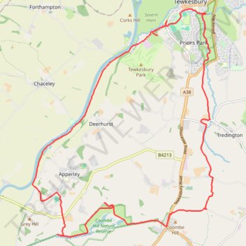
Loop hike from Tewkesbury
- Distance: 22.2 Km
- Elevation gain: 115 m
- Maximum elevation: 45 m
- Elevation loss: 115 m
- Minimum elevation: 7 m
- Moving time: 4 h 27 m
- Moving speed: 5.0 Km/h
- Maximum speed: 8.2 Km/h
- Total time: 5 h 54 m
- Global speed: 3.8 Km/h
Interactive trail map
Trail profile
- Distance: 22.2 Km
- Elevation gain: 115 m
- Maximum elevation: 45 m
- Elevation loss: 115 m
- Minimum elevation: 7 m
- Moving time: 4 h 27 m
- Moving speed: 5.0 Km/h
- Maximum speed: 8.2 Km/h
- Total time: 5 h 54 m
- Global speed: 3.8 Km/h
About this trail
Name: Loop hike from Tewkesbury trail, distance, elevation, map, profile, GPS track
Coordinates: 51.93944 -2.21384 51.99191 -2.14611
Other hiking, mountain biking, running and outdoor activity trails
Click on a trail to view its statistics, map and profile.
Dean2023-311
United Kingdom > England > Oxfordshire > Oxford
Distance: 310.3 Km • Elevation gain: 3,366 m • Maximum elevation: 290 m