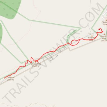
Kanahau round trip from Haleakala Summit
- Distance: 13.7 Km
- Elevation gain: 561 m
- Maximum elevation: 3,049 m
- Elevation loss: 558 m
- Minimum elevation: 2,622 m
- Moving time: 3 h 7 m
- Moving speed: 4.4 Km/h
- Maximum speed: 11.1 Km/h
- Total time: 3 h 53 m
- Global speed: 3.5 Km/h
Interactive trail map
Trail profile
- Distance: 13.7 Km
- Elevation gain: 561 m
- Maximum elevation: 3,049 m
- Elevation loss: 558 m
- Minimum elevation: 2,622 m
- Moving time: 3 h 7 m
- Moving speed: 4.4 Km/h
- Maximum speed: 11.1 Km/h
- Total time: 3 h 53 m
- Global speed: 3.5 Km/h
About this trail
Name: Kanahau round trip from Haleakala Summit trail, distance, elevation, map, profile, GPS track
Start: Crater Road, Maui County, Hawaii, United States (20.71019 -156.25255)
End: ハレアカラ国立公園, Crater Road, Maui County, Hawaii, United States (20.71002 -156.25294)
Coordinates: 20.68927 -156.29597 20.71022 -156.25132