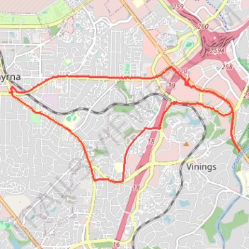
Bicycle ride around Smyrna, mostly on bike trails
- Distance: 16.6 Km
- Elevation gain: 233 m
- Maximum elevation: 333 m
- Elevation loss: 233 m
- Minimum elevation: 232 m
- Moving time: 1 h 16 m
- Moving speed: 13.1 Km/h
- Maximum speed: 38.7 Km/h
- Total time: 1 h 28 m
- Global speed: 11.3 Km/h
Interactive trail map
Trail profile
- Distance: 16.6 Km
- Elevation gain: 233 m
- Maximum elevation: 333 m
- Elevation loss: 233 m
- Minimum elevation: 232 m
- Moving time: 1 h 16 m
- Moving speed: 13.1 Km/h
- Maximum speed: 38.7 Km/h
- Total time: 1 h 28 m
- Global speed: 11.3 Km/h
About this trail
Name: Bicycle ride around Smyrna, mostly on bike trails trail, distance, elevation, map, profile, GPS track
Coordinates: 33.86137 -84.51339 33.88584 -84.45459
Other hiking, mountain biking, running and outdoor activity trails
Click on a trail to view its statistics, map and profile.
Ride from Smyrna to Marietta on the Mountain to River Trail
United States > Georgia > Cobb County > Smyrna
Distance: 21.9 Km • Elevation gain: 129 m • Maximum elevation: 352 m
Bike ride to bus stop to go into town, then circle back along the silver comet trail and ride the newly paved part of the beltline connector
United States > Georgia > Cobb County > Smyrna
Distance: 24.0 Km • Elevation gain: 273 m • Maximum elevation: 333 m
Atlanta, Lilburn, Yellow River Park, Panola, Jonesboro
United States > Georgia > Fayette County > Peachtree City > Stop
Distance: 335.0 Km • Elevation gain: 4,058 m • Maximum elevation: 338 m
A Better Cobb Group Ride - Mountain to River Trail
United States > Georgia > Cobb County > Smyrna
Distance: 29.6 Km • Elevation gain: 220 m • Maximum elevation: 353 m