North Tripyramid, Middle Tripyramid and South Tripyramid
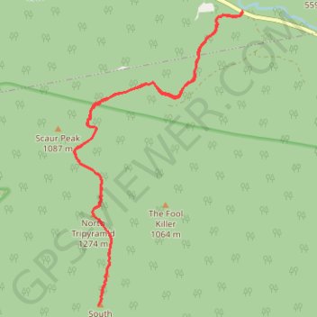
Starting from the Pine Bend Brook Trailhead on the Kancamagus Highway, the route enters the White Mountain National Forest and follows Pine Bend Brook into the Sandwich Range Wilderness, moving through a quiet forested drainage below Scaur Peak and The Fool Killer.
The climb then steepens toward the Tripyramid ridge, where the itinerary reaches North Tripyramid before continuing along the Mount Tripyramid Trail across wooded high ground and occasional outlooks to Middle Tripyramid.
Beyond Middle Tripyramid, the trail carries on to South Tripyramid, completing a rugged White Mountains traverse shaped by brook crossings, dense northern forest, rocky ascent, and the distinctive three-summit profile of Mount Tripyramid.
#Hiking #Mountain #Nature #Forest #Wilderness #Summit #Ridge #Brook
- Distance: 15.4 Km
- Elevation gain: 1,020 m
- Maximum elevation: 1,244 m
- Elevation loss: 1,020 m
- Minimum elevation: 417 m
- Moving time: 4 h 52 m
- Moving speed: 3.2 Km/h
- Maximum speed: 5.6 Km/h
- Total time: 6 h 14 m
- Global speed: 2.5 Km/h
Interactive trail map
Trail profile
- Distance: 15.4 Km
- Elevation gain: 1,020 m
- Maximum elevation: 1,244 m
- Elevation loss: 1,020 m
- Minimum elevation: 417 m
- Moving time: 4 h 52 m
- Moving speed: 3.2 Km/h
- Maximum speed: 5.6 Km/h
- Total time: 6 h 14 m
- Global speed: 2.5 Km/h
About this trail
Name: North Tripyramid, Middle Tripyramid and South Tripyramid trail, distance, elevation, map, profile, GPS track
Start: Kancamagus Highway, Livermore, Grafton County, New Hampshire, United States (44.00196 -71.41320)
End: Kancamagus Highway, Livermore, Grafton County, New Hampshire, United States (44.00192 -71.41320)
Coordinates: 43.96011 -71.44643 44.00196 -71.41309
Other hiking, mountain biking, running and outdoor activity trails
Click on a trail to view its statistics, map and profile.
Tripyramid Mountains Loop
United States > New Hampshire > Grafton County > Waterville Valley
Loop hike from Livermore South Trailhead to North Tripyramid, Middle Tripyramid and South Tripyramid via Livermore Road, Avalanche Brook, Mount Tripyramid Trail and Slide Brook in the Sandwich Range Wilderness. #Hiking #Loop #Mountain #Forest #Nature #Wilderness
Distance: 17.1 Km • Elevation gain: 854 m • Maximum elevation: 1,246 m