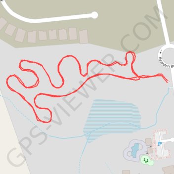
Walking of newly constructed walking path near Jarrell, TX
- Distance: 1.6 Km
- Elevation gain: 7 m
- Maximum elevation: 243 m
- Elevation loss: 7 m
- Minimum elevation: 237 m
- Moving time: 16 m 51 s
- Moving speed: 5.9 Km/h
- Maximum speed: 7.0 Km/h
- Total time: 16 m 51 s
- Global speed: 5.9 Km/h
Interactive trail map
Trail profile
- Distance: 1.6 Km
- Elevation gain: 7 m
- Maximum elevation: 243 m
- Elevation loss: 7 m
- Minimum elevation: 237 m
- Moving time: 16 m 51 s
- Moving speed: 5.9 Km/h
- Maximum speed: 7.0 Km/h
- Total time: 16 m 51 s
- Global speed: 5.9 Km/h
About this trail
Name: Walking of newly constructed walking path near Jarrell, TX trail, distance, elevation, map, profile, GPS track
Coordinates: 30.81303 -97.58256 30.81400 -97.58001