Thank you for supporting this site ❤️
Make a donation
Make a donation
Gear up for your next adventure:
As an Amazon Associate, this site earns from qualifying purchases at no extra cost to you.
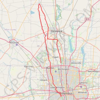
ThrottleCo_River_Roads_Loop
- Distance: 106.6 Km
- Elevation gain: 413 m
- Maximum elevation: 300 m
- Elevation loss: 394 m
- Minimum elevation: 216 m
Interactive trail map
Thank you for supporting this site ❤️
Make a donation
Make a donation
Gear up for your next adventure:
As an Amazon Associate, this site earns from qualifying purchases at no extra cost to you.
Trail profile
- Distance: 106.6 Km
- Elevation gain: 413 m
- Maximum elevation: 300 m
- Elevation loss: 394 m
- Minimum elevation: 216 m
Thank you for supporting this site ❤️
Make a donation
Make a donation
Gear up for your next adventure:
As an Amazon Associate, this site earns from qualifying purchases at no extra cost to you.
About this trail
Name: ThrottleCo_River_Roads_Loop trail, distance, elevation, map, profile, GPS track
Coordinates: 39.94580 -83.19751 40.44543 -83.02826
Thank you for supporting this site ❤️
Make a donation
Make a donation
Gear up for your next adventure:
As an Amazon Associate, this site earns from qualifying purchases at no extra cost to you.