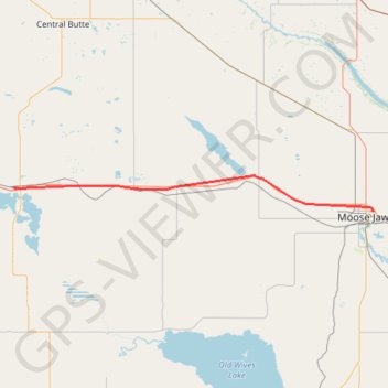
Chaplin - Moose Jaw
Interactive trail map
Trail profile
- Distance: 85.6 Km
- Elevation gain: 158 m
- Maximum elevation: 705 m
- Elevation loss: 261 m
- Minimum elevation: 565 m
About this trail
Name: Chaplin - Moose Jaw trail, distance, elevation, map, profile, GPS track
Start: Chaplin Village Campground, 1st Avenue, Chaplin, Saskatchewan, S0H 0V0, Canada (50.45785 -106.66231)
End: Fairview, Moose Jaw, Saskatchewan, S6H 7B2, Canada (50.41060 -105.50927)
Coordinates: 50.41060 -106.66232 50.48337 -105.50927
Topography: Saskatchewan topographic map, elevation, terrain
Other hiking, mountain biking, running and outdoor activity trails
Click on a trail to view its statistics, map and profile.
Swift Current - Chaplin
Canada > Saskatchewan > Swift Current > Swift Current
Distance: 87.6 Km • Elevation gain: 245 m • Maximum elevation: 774 m
Moose Jaw - Regina
Canada > Saskatchewan > Moose Jaw
#Bike
Distance: 71.0 Km • Elevation gain: 117 m • Maximum elevation: 583 m