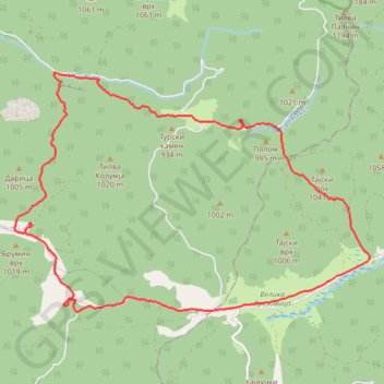
Kučaj: Velika Brezovica, Valkaluci, Nekudovo, vodopad Prskal...
- Distance: 21.7 Km
- Elevation gain: 544 m
- Maximum elevation: 979 m
- Elevation loss: 544 m
- Minimum elevation: 731 m
- Moving time: 5 h 9 m
- Moving speed: 4.2 Km/h
- Maximum speed: 17.0 Km/h
- Total time: 6 h 59 m
- Global speed: 3.1 Km/h
Interactive trail map
Trail profile
- Distance: 21.7 Km
- Elevation gain: 544 m
- Maximum elevation: 979 m
- Elevation loss: 544 m
- Minimum elevation: 731 m
- Moving time: 5 h 9 m
- Moving speed: 4.2 Km/h
- Maximum speed: 17.0 Km/h
- Total time: 6 h 59 m
- Global speed: 3.1 Km/h
About this trail
Name: Kučaj: Velika Brezovica, Valkaluci, Nekudovo, vodopad Prskal... trail, distance, elevation, map, profile, GPS track
Coordinates: 43.95676 21.70284 43.99612 21.78388
Other hiking, mountain biking, running and outdoor activity trails
Click on a trail to view its statistics, map and profile.
2022_Yu
Slovenia > Ajdovščina > Žapuže
Distance: 2,457.3 Km • Elevation gain: 32,048 m • Maximum elevation: 1,950 m