Thank you for supporting this site ❤️
Make a donation
Make a donation
Gear up for your next adventure:
As an Amazon Associate, this site earns from qualifying purchases at no extra cost to you.
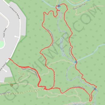
The Cambourne Loop
Interactive trail map
Thank you for supporting this site ❤️
Make a donation
Make a donation
Gear up for your next adventure:
As an Amazon Associate, this site earns from qualifying purchases at no extra cost to you.
Trail profile
- Distance: 4.5 Km
- Elevation gain: 139 m
- Maximum elevation: 135 m
- Elevation loss: 130 m
- Minimum elevation: 37 m
- Moving time: 1 h 14 m
- Moving speed: 3.6 Km/h
- Maximum speed: 8.7 Km/h
- Total time: 1 h 22 m
- Global speed: 3.2 Km/h
Thank you for supporting this site ❤️
Make a donation
Make a donation
Gear up for your next adventure:
As an Amazon Associate, this site earns from qualifying purchases at no extra cost to you.
About this trail
Name: The Cambourne Loop trail, distance, elevation, map, profile, GPS track
Coordinates: -33.72759 151.18238 -33.71882 151.19190
Thank you for supporting this site ❤️
Make a donation
Make a donation
Gear up for your next adventure:
As an Amazon Associate, this site earns from qualifying purchases at no extra cost to you.
Other hiking, mountain biking, running and outdoor activity trails
Click on a trail to view its statistics, map and profile.