Make a donation
Gear up for your next adventure:
As an Amazon Associate, this site earns from qualifying purchases at no extra cost to you.
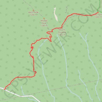
Mount Osceola and East Peak in White Mountain National Forest
The hike to Mount Osceola and East Peak offers a moderately challenging route through the scenic White Mountains, with impressive views of the Waterville Valley and surrounding peaks like the Sandwich Range. The climb begins with a steady ascent through forested terrain, with rocky sections that become more exposed as you approach the summit of Mount Osceola. From the top, hikers are rewarded with panoramic vistas, while the additional stretch to East Peak provides a quieter, more rugged experience, including a rock scramble down the Osceola Chimney before reaching the second summit. #Hiking #Mountain #Forest #Nature #Overlook
- Distance: 12.7 Km
- Elevation gain: 846 m
- Maximum elevation: 1,309 m
- Elevation loss: 846 m
- Minimum elevation: 702 m
- Moving time: 3 h 12 m
- Moving speed: 4.0 Km/h
- Maximum speed: 8.6 Km/h
- Total time: 3 h 56 m
- Global speed: 3.2 Km/h
Interactive trail map
Make a donation
Gear up for your next adventure:
As an Amazon Associate, this site earns from qualifying purchases at no extra cost to you.
Trail profile
- Distance: 12.7 Km
- Elevation gain: 846 m
- Maximum elevation: 1,309 m
- Elevation loss: 846 m
- Minimum elevation: 702 m
- Moving time: 3 h 12 m
- Moving speed: 4.0 Km/h
- Maximum speed: 8.6 Km/h
- Total time: 3 h 56 m
- Global speed: 3.2 Km/h
Make a donation
Gear up for your next adventure:
As an Amazon Associate, this site earns from qualifying purchases at no extra cost to you.
About this trail
Name: Mount Osceola and East Peak in White Mountain National Forest trail, distance, elevation, map, profile, GPS track
Coordinates: 43.98324 -71.55939 44.00607 -71.52058
Make a donation
Gear up for your next adventure:
As an Amazon Associate, this site earns from qualifying purchases at no extra cost to you.
Other hiking, mountain biking, running and outdoor activity trails
Click on a trail to view its statistics, map and profile.