Blue Bell Pass via Bullion Basin Trail
This hike to Blue Bell Pass offers an immersive experience in the rugged beauty of the Mount Baker-Snoqualmie National Forest. As you ascend, you'll traverse lush meadows filled with wildflowers and enjoy sweeping views of the surrounding mountains, including Crystal Mountain and peaks of the North Cascades. The trail also leads you past historical remnants from past mining activities, providing a mix of natural and cultural sights, with a rewarding vista from the pass itself. #Hiking #Mountain #Forest #Nature
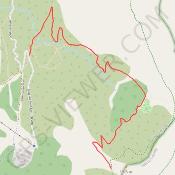
- Distance: 3.6 Km
- Elevation gain: 470 m
- Maximum elevation: 1,903 m
- Elevation loss: 23 m
- Minimum elevation: 1,455 m
Interactive trail map
Trail profile
- Distance: 3.6 Km
- Elevation gain: 470 m
- Maximum elevation: 1,903 m
- Elevation loss: 23 m
- Minimum elevation: 1,455 m
About this trail
Name: Blue Bell Pass via Bullion Basin Trail trail, distance, elevation, map, profile, GPS track
Start: Bullion Basin Trail, Pierce County, Washington, United States (46.93818 -121.46830)
End: Bullion Basin Trail, Pierce County, Washington, United States (46.92878 -121.45840)
Coordinates: 46.92878 -121.46830 46.94222 -121.45411
Other hiking, mountain biking, running and outdoor activity trails
Click on a trail to view its statistics, map and profile.
Crown Point Loop via Bullion Basin Trail, Pacific Crest Trail and Silver Creek Trail
United States > Washington > Pierce County
The Crown Point Loop hike offers an immersive journey through some of the most beautiful alpine terrain in the Mount Baker-Snoqualmie National Forest. Starting with the Bullion Basin Trail, you'll wind through lush meadows and dense forests before reaching the ridge for expansive views. As you follow the…
Distance: 11.9 Km • Elevation gain: 711 m • Maximum elevation: 1,927 m
Northern part of the Pacific Crest Trail (PCT)
United States > Oregon > Klamath County
Hike on the Pacific Crest National Scenic Trail from Crater Lake to Canada Border through Oregon and Washington along the Sierra Nevada and Cascade mountain ranges. #Hiking #Mountain #SierraNevada #Cascade #Nature #Forest #Park #PCT
Distance: 1,198.3 Km • Elevation gain: 44,308 m • Maximum elevation: 2,307 m